| * Rob Milne used a simple GPS, likely using barometric pressure as well
as satellites for altitude, which is not reliable at this latitude. Damien
Gildea remeasured Vinson as well as Mt Shinn with a better unit (see below). The
height for Vinson was 4892.17m. Full Lat/Long was 78 31 31.74 S 85 37 01.73 W,
which is the only waypoint that is off from Rob Milne's.
Damiens GPS ran on the highest piece of solid rock, about 3m south of the
snow mound with the pole in it. The crest of the mound is maybe 1m or less
higher than the top of the rock.
In the words of Damien, from different publications and emails:
"But really this is within the +/-5m that the USGS put on such heights
anyway, at least for Antarctica, so we are not claiming anything dramatic.
We also measured the sub-peaks of Vinson (9 of them, only one previously
climbed) and found that 'Kershaw Peak' was only 27m lower than Vinson main
summit. But those sub-peaks are not really individual mountains, just peaks, so
Tyree is still the real #2."
"Mt. Shinn has long been considered Antarctica’s third highest mountain. The
first surveys of the Ellsworth Mountains were done by US parties during the
1961-62 season, when the first ascents of mountains in the range were also done.
The area was re-surveyed in the 1979-80 season, again by a US party. This
expedition included, however, two German and one Soviet climber, who climbed to
the summit of Vinson Massif in the course of their work. They placed a ski-pole
and red flag on the summit, which assisted the ground parties in obtaining a
height for Vinson that was more accurate than had previously been ascertained.
Thus the height of Vinson’s main summit was reduced from 5140m to 4897m. The
official height of Mt. Tyree was also reduced to 4852m, but no height was ever
published for Mt. Shinn – either before or after the 1979 work." (from the Shinn
report on
the
Omega foundation site)
In 2002 Shinn's height was 4660.508m. Full Lat/Long was 78 27 48.8 S 85 43
28.9 W
Note: All the camp readings were on snow/ice. Vinson Main Summit was on rock.
Our system is a lot more detailed than any handheld GPS, even when the
handheld is using the satellites for altitude, let alone when it is going by
barometer. Our unit is a Trimble 5700, an updated model of what was used on
Everest a few years back by Bradford Washburn et al. Details at
www.trimble.com and also in the older Shinn
section of
www.theomegafoundation.org"

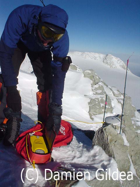
Measuring Vinsons altitude at the summit (aboit one meter below the snow
summit). Picture by Damien Gildea, the climber in the pic is Camilo Rada.
Damien Gildea is the author of ‘The Antarctic Mountaineering Chronology’
(1998), the only reference book dealing specifically with ascents of the peaks
of Antarctica and South Georgia.
|

