








The standard route, followed by almost all Denali climbers (96% in 2025): nine stages from the flight in to Kahiltna Base Camp all the way to the 6,190 m summit and back.
The West Buttress is the route this guide describes in detail, the one Bradford Washburn pioneered in 1951 and that the great majority of Denali climbers now follow — in a recent season 922 of 960 registered climbers, around 96%, went up the West Buttress. Below we describe the entire route from Talkeetna to the summit and back, section by section. Each section is not necessarily climbed in a single day: some stretches are too long, especially for a first ascent, and there are many opportunities for alternative camps along the way. The camp that suits your team depends on the weather, your physical state and the condition of the glaciers.
Before you go: the permit and fees are on Denali permits and costs, and the seven licensed guide companies are on Denali operators.
The route timings given at the head of each stage are very rough estimates that vary widely with conditions, and the length of a daily stretch is determined above all by your climbing strategy, cache-and-carry versus single loads. Remember that each section is described only once, although in practice you may climb it several times, going faster each time.
A note on camp names
Several campsites are known by a variety of names, often referring to altitude, Motorcycle Hill Camp is also called 11K Camp because it sits at 11,000 ft, and the name ‘Base Camp’ can mean either of two camps over 2000 vertical metres apart. This table shows the main variants and altitudes:
Ski-planes land climbers and gear directly on the Kahiltna Glacier.
| Camp | Also known as | Metres | Feet |
|---|---|---|---|
| Kahiltna Base Camp | Kahiltna / Denali International Airport, Base Camp, BC | 2200 | 7200 |
| Ski Hill | Camp 1, 7800 ft Camp, 8000 ft Camp, Base of Ski Hill | 2375 | 7800 |
| Kahiltna Pass | 9700 ft Camp, 10K Camp, Below Kahiltna Pass Camp | 2950 | 9700 |
| Motorcycle Hill Camp | 11,000 ft Camp, 11K Camp | 3350 | 11,000 |
| Windy Corner Camp | Around Windy Corner | 4115 | 13,500 |
| Basin Camp | Medical Camp, 14K Camp, Advanced Base Camp (ABC), Genet Basin | 4330 | 14,200 |
| Ridge Camp | 16K Camp | 5000 | 16,400 |
| High Camp | 17,000 ft Camp, 17K Camp | 5245 | 17,200 |
Each stage page below opens with a box summarizing the typical time, altitude gained, grade and terrain, and a one-line summary of what the section is like.
In this section
Maps & profiles
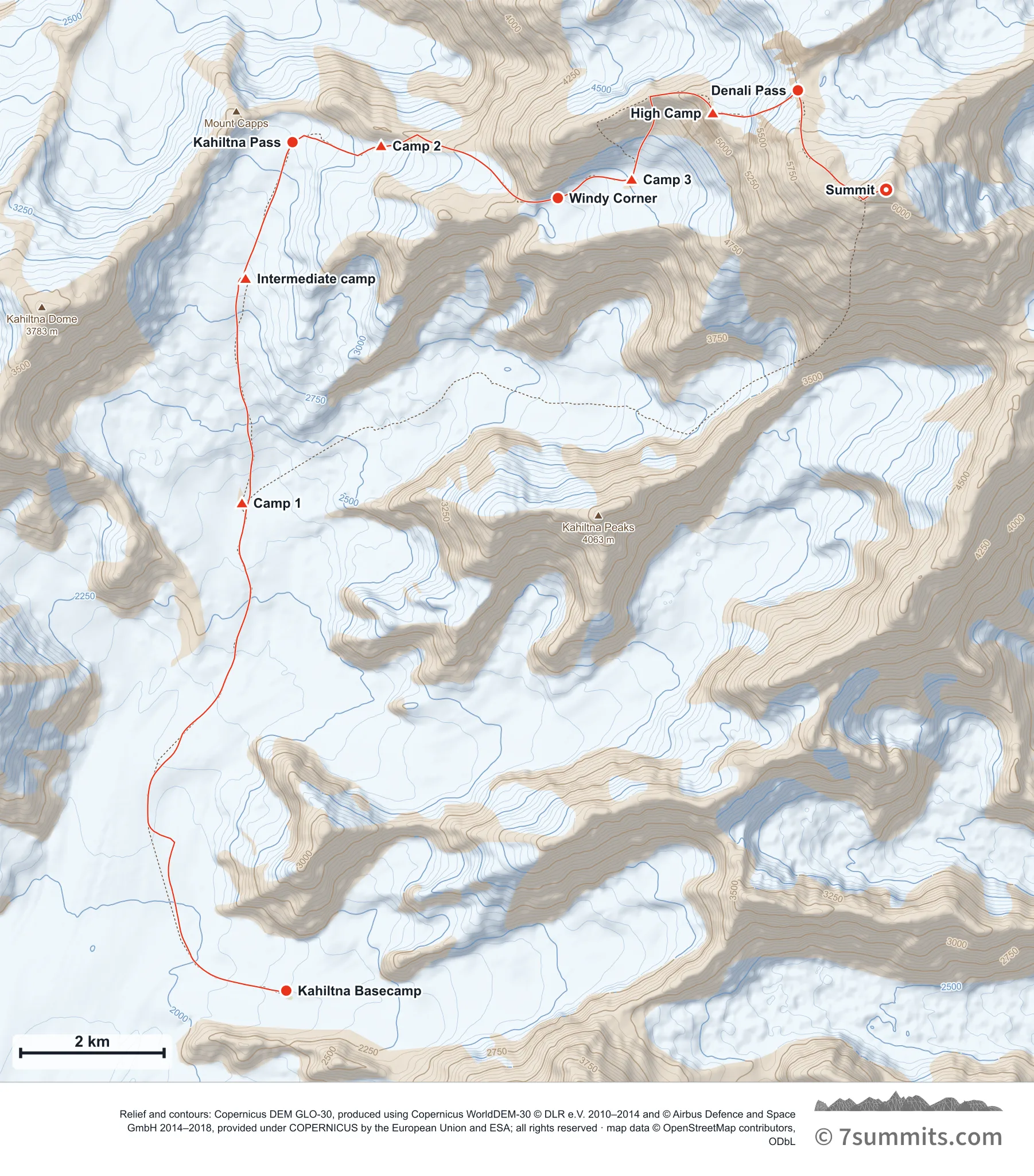
Point at the route or drag along the profile to see the height and the distance walked.
GPX files
Download the West Buttress track
CAMP POSITIONS ARE APPROXIMATE AND NOT FIXED. On a glacier there is no such thing as a permanent camp site: the ice is moving, and crevasses and snow bridges open, close and rot out between seasons and within a single season. A spot that was a safe, well-used camp one year can be dangerous the next, or later in the same year. These coordinates indicate roughly where camps are commonly sited: they are not an instruction to camp at a point. Always probe the area thoroughly yourself before making camp. Never treat a coordinate as evidence that ground is safe.
Navigation aid only, not a substitute for your own judgement, current conditions or local knowledge. Elevations are modelled from open terrain data, not surveyed.
Sources, credits and licence
Route geometry derived from public GPS traces © OpenStreetMap contributors (ODbL). Elevation data © Mapzen Terrain Tiles, sourced from USGS, NASA SRTM/ASTER and NOAA.. Licence: ODbL 1.0. Source data
Waypoints
WGS84 decimal degrees. Elevations are modelled from open terrain data (roughly 20–50 m low on snow and ice), not published camp altitudes: read them as approximate positions, not pitches.
| Waypoint | Latitude | Longitude | m | ft |
|---|---|---|---|---|
| Kahiltna Basecamp (7,200 ft) | 62.96876 | -151.17187 | 2,195 | 7,201 |
| Camp 1 (7,800 ft) | 63.02990 | -151.18410 | 2,377 | 7,799 |
| Intermediate camp (~9,350 ft, optional) | 63.05800 | -151.18310 | 2,850 | 9,350 |
| Kahiltna Pass (10,000 ft) | 63.07507 | -151.17015 | 3,048 | 10,000 |
| Camp 2 (11,000 ft) | 63.07460 | -151.14568 | 3,353 | 11,001 |
| Windy Corner (13,500 ft) | 63.06807 | -151.09688 | 4,115 | 13,501 |
| Camp 3 (14,200 ft) | 63.07040 | -151.07650 | 4,328 | 14,199 |
| High Camp (17,200 ft) | 63.07870 | -151.05410 | 5,243 | 17,201 |
| Denali Pass (18,200 ft) | 63.08154 | -151.03062 | 5,547 | 18,199 |
| Summit (20,310 ft) | 63.06911 | -151.00624 | 6,190 | 20,308 |
Links to other people’s recordings, hosted by them. Compare and cross-check: never assume any single line is safe.