GuidebooksThe listsOperatorsForumGearLibraryNews
Search

Guidebooks

  • Everest8,849 m
  • Aconcagua6,961 m
  • Denali6,190 m
  • Kilimanjaro5,895 m
  • Elbrus5,642 m
  • Vinson4,892 m
  • Carstensz Pyramid4,884 m
  • Kosciuszko2,228 m

  • Offline expedition packs
  • Statistics
  • Trip reports

The lists

  • The 7 summits›
  • All finishers798
  • Kosciuszko list453also the Bass list
  • Carstensz list558also the Messner list
  • 8 Summits248both
  • Apply for the list

  • Bass vs. Messner
  • Leaderboards
  • Women
  • Men

Operators

  • DirectoryEvery 7summits company
  • Compare operatorsSide by side, and what to ask

For companies

  • Add your company
  • Claim your listing
  • Become a partner

Forum

  • Forum home
  • The 7 summits›
  • Planning your climb›
  • Gear›
  • The community›
  • Members' lounge›

  • Leaderboard
  • Community guidelines

Gear

  • All gear
  • My gear shed
  • My trip duffels

Gear lists

  • Everest
  • Aconcagua
  • Denali
  • Kilimanjaro
  • Elbrus
  • Vinson
  • Carstensz
  • Kosciuszko

Library

  • Books & films
  • FAQ
  • Climbing glossary
  • Trivia quiz
  • QuotesInspiration

Featured

Book of the WeekSeven SummitsDick BassView in the Library →

News & Blog

  • All posts
  • News
  • Series

7summits.com

  • About us
  • Membership
  • Roadmap
  • Support us
  • Contact

7summits.com

Authoritative guides, the world's best finisher database, and community, for everyone who dreams of the 7 summits.

Support 7summits

Explore

  • Guidebooks
  • Library
  • Finishers
  • Finisher badge
  • FAQ
  • 7summits hub
  • Operators
  • Membership
  • Supporters
  • About
  • Partner with us
  • Roadmap
  • Quotes

Legal

  • Privacy
  • Disclaimer
  • Terms & Conditions
  • Community guidelines
  • Contact
© 2026 7summits.comAffiliate disclosure ↗
Home › Aconcagua › Aconcagua map

Aconcagua map

Where Aconcagua is, and each route we map on it with the camps marked. Every map opens larger, and each group links to the chapter that describes the route.

Where Aconcagua is

Where on Earth: Aconcagua, one of the 7 summits. · Imagery: NASA Earth Observatory “Blue Marble” · borders: Natural Earth (public domain)

Aconcagua: Overview

Aconcagua within South America. · Imagery: NASA Earth Observatory “Blue Marble” · borders: Natural Earth (public domain)
The two routes this guide describes: the Normal Route up the Horcones Valley to Plaza de Mulas, and the Polish Traverse up the Vacas Valley to Plaza Argentina. The technical Polish Glacier lines leave the Traverse high on the mountain and are not drawn. Navigation aid only, not for wayfinding. · © MapTiler © OpenStreetMap contributors

Read the chapter: Aconcagua: Overview

Normal Route

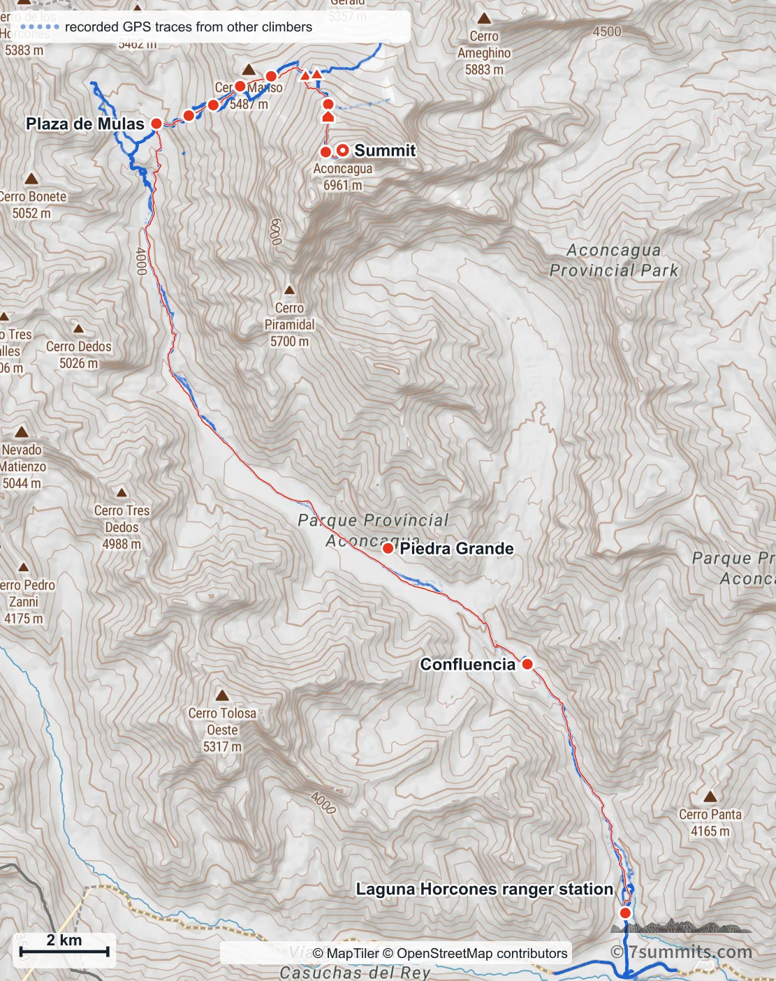
Topographic map of the Normal Route on Aconcagua, from the Laguna Horcones ranger station up the Horcones valley past Confluencia and Piedra Grande to Plaza de Mulas base camp, then climbing north-east through a close-set line of high camps to the summit

Point at the route or drag along the profile to see the height and the distance walked.

The Normal Route from the Laguna Horcones ranger station to the summit. Every stop is marked; the upper camps are named on the closer views below, where they are far enough apart to read. The faint blue is real recorded GPS from other climbers: our line is one ascent, and where the blue spreads away from it, on the valley flats, that is the braid of paths people actually walk. Navigation aid only, not for wayfinding. · © MapTiler © OpenStreetMap contributors
The whole route from almost overhead, north at the top. Seen this way the shape of it is plain: fifteen kilometres north up the Horcones valley, a turn west to Plaza de Mulas, and only then the climb. The dark wall below the summit is the South Face: the Normal Route never touches it. The dashed line to the west is the Chilean border: the mountain is wholly in Argentina, and you walk in from Ruta 7 at the bottom of the picture. · Elevation data © Copernicus DEM (GLO-30) · peak names © OpenStreetMap contributors

Read the chapter: Normal Route

Confluencia to Plaza de Mulas

The walk in, north at the top: from the ranger station up the Horcones valley to Confluencia, then the long haul to Plaza de Mulas. No climbing on this half, but it is where the acclimatization is won or lost, and Aconcagua is in sight at the head of the valley for most of it. · Elevation data © Copernicus DEM (GLO-30) · peak names © OpenStreetMap contributors

Read the chapter: Confluencia to Plaza de Mulas

Plaza de Mulas to Plaza Cañada

The climbing half, seen from the west: the side the route actually goes up. The scree slopes above base camp, the change of slope at Cambio de Pendiente, and the traverse across the top of the Gran Acarreo to the foot of the Canaleta. · Elevation data © Copernicus DEM (GLO-30) · peak names © OpenStreetMap contributors

Read the chapter: Plaza de Mulas to Plaza Cañada

Summit day

Summit day: past Independencia, then the long traverse across the top of the Gran Acarreo (which the guide warns is not the way down) to the cave at the foot of the Canaleta and the final gully. · Elevation data © Copernicus DEM (GLO-30) · peak names © OpenStreetMap contributors

Read the chapter: Summit day

Vacas Valley routes

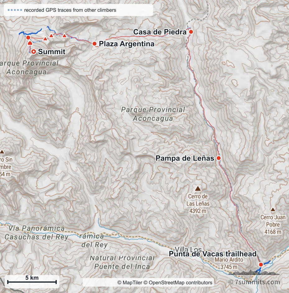
Topographic map of the Polish Traverse on Aconcagua, from the Punta de Vacas trailhead up the Vacas valley past Pampa de Leñas and Casa de Piedra to Plaza Argentina base camp, then climbing west through Camp 1, the Col Camp and Camp 2 and crossing to Rocas Blancas to join the Normal Route for the summit

Point at the route or drag along the profile to see the height and the distance walked.

The Polish Traverse (Falso de los Polacos), from Punta de Vacas up the Vacas valley to Plaza Argentina base camp, then west through the high camps and across to Rocas Blancas, where it joins the Normal Route for the summit. This page covers two routes and only one is drawn: the Polish Glacier proper is a technical ice climb, and it is not this line. The upper camps are marked but not named (at this width their labels would overprint) and each is named with its coordinates in the table below. The faint blue is real recorded GPS from other climbers, visible where their tracks spread away from ours; along the valley it lies underneath it. The short crossing from Camp 2 west to Rocas Blancas has almost no recorded GPS behind it, so that stretch is indicative rather than surveyed. Navigation aid only, not for wayfinding. · © MapTiler © OpenStreetMap contributors

Read the chapter: Vacas Valley routes

Using these maps

7summits.com draws these maps from GPS tracks and open elevation data, and each one carries the credit its sources ask for. To use one in print or on another site, ask us first. Get in touch
Plan this climb

See the operators who guide this peak, and what each trip includes.

Find an operator

Run expeditions, or make something climbers rely on?

Partner with us →

From the library

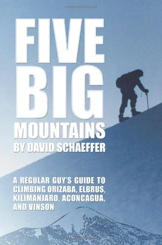
Five Big Mountains: A Regular Guy's Guide to Climbing Orizaba, Elbrus, Kilimanjaro, Aconcagua, and VinsonDavid N. SchaefferFor Aconcagua

See detailsGo to the library

Book of the Week

Seven SummitsDick Bass

See detailsGo to the library

Support 7summits

This site is kept going by its readers. Give once, any amount.

Support us

Finished the 7?

Apply to be listed
Share this page
EmailWhatsApp

Spotted something? Help us make this page better.

  • Correction or missing information
  • Photo, GPX or file
  • Something else

The 7 summits mailing list

Sign up for the 7 summits mailing list (7 summits news, operator info, regulations & permits, gear, site updates and more)

Nothing is sent until you confirm. Every mailing has a one-click unsubscribe link.

GuidebooksThe listsOperatorsForumGearLibraryNews
Search

Guidebooks

  • Everest8,849 m
  • Aconcagua6,961 m
  • Denali6,190 m
  • Kilimanjaro5,895 m
  • Elbrus5,642 m
  • Vinson4,892 m
  • Carstensz Pyramid4,884 m
  • Kosciuszko2,228 m

  • Offline expedition packs
  • Statistics
  • Trip reports

The lists

  • The 7 summits›
  • All finishers798
  • Kosciuszko list453also the Bass list
  • Carstensz list558also the Messner list
  • 8 Summits248both
  • Apply for the list

  • Bass vs. Messner
  • Leaderboards
  • Women
  • Men

Operators

  • DirectoryEvery 7summits company
  • Compare operatorsSide by side, and what to ask

For companies

  • Add your company
  • Claim your listing
  • Become a partner

Forum

  • Forum home
  • The 7 summits›
  • Planning your climb›
  • Gear›
  • The community›
  • Members' lounge›

  • Leaderboard
  • Community guidelines

Gear

  • All gear

Gear lists

  • Everest
  • Aconcagua
  • Denali
  • Kilimanjaro
  • Elbrus
  • Vinson
  • Carstensz
  • Kosciuszko

Library

  • Books & films
  • FAQ
  • Climbing glossary
  • Trivia quiz
  • QuotesInspiration

Featured

Book of the WeekSeven SummitsDick BassView in the Library →

News & Blog

  • All posts
  • News
  • Series

7summits.com

  • About us
  • Membership
  • Roadmap
  • Support us
  • Contact
Sign inRegister