








The route most Aconcagua climbers take, up the Horcones valley: stage by stage from Puente del Inca through Confluencia, Plaza de Mulas and the high camps to summit day, and back down.
The Normal Route (also known as the Horcones Valley Route or the Northwest Ridge) is the most frequently climbed path to the summit of Aconcagua (6,961 m / 22,838 ft22,838 ft), the highest peak in both the Western and Southern Hemispheres. Approached through the Horcones Valley in Argentina's Mendoza Province, this non-technical route draws thousands of climbers each season, from seasoned high-altitude veterans to ambitious trekkers making their first foray into the 7 summits. While it requires no roped glacier travel or technical ice climbing, do not be deceived by its reputation for accessibility, the extreme altitude, notoriously fierce Viento Blanco winds, and long summit days make Aconcagua a serious mountaineering objective demanding thorough preparation.
The typical itinerary begins at the Horcones trailhead (2,950 m / 9,678 ft9,678 ft) inside Aconcagua Provincial Park, following a well-marked trail to Plaza de Mulas Base Camp (4,300 m / 14,108 ft14,108 ft), the largest base camp in the world outside of the Himalaya. From there, climbers establish a series of high camps at Nido de Cóndores (~5,400 m / 17,717 ft17,717 ft) and Camp Cólera (5,950 m / 19,521 ft19,521 ft) and Berlín (5,930 m / 19,455 ft19,455 ft) before launching a grueling summit push via the infamous Canaleta gully. A complete expedition typically spans 18–22 days, incorporating essential acclimatization rotations to maximise summit success rates and minimise the risks of altitude sickness.
Permits are mandatory and are issued by the Mendoza provincial government. For foreign climbers the 2025-26 ascent permit via Horcones cost USD 1,170 with a registered company and USD 1,640 without; the current fees, and how to buy a permit, are on Aconcagua permits and costs. Guided expeditions typically cost several thousand dollars on top, depending on the operator and service level: compare them on the Aconcagua operators page. Climbing permits are issued for entry between 1 December and 15 February, with January offering the most stable weather windows. Whether this is your first big mountain or the next one on your 7 summits list, the Normal Route on Aconcagua rewards patience and disciplined acclimatization.
In this section
Maps & profiles
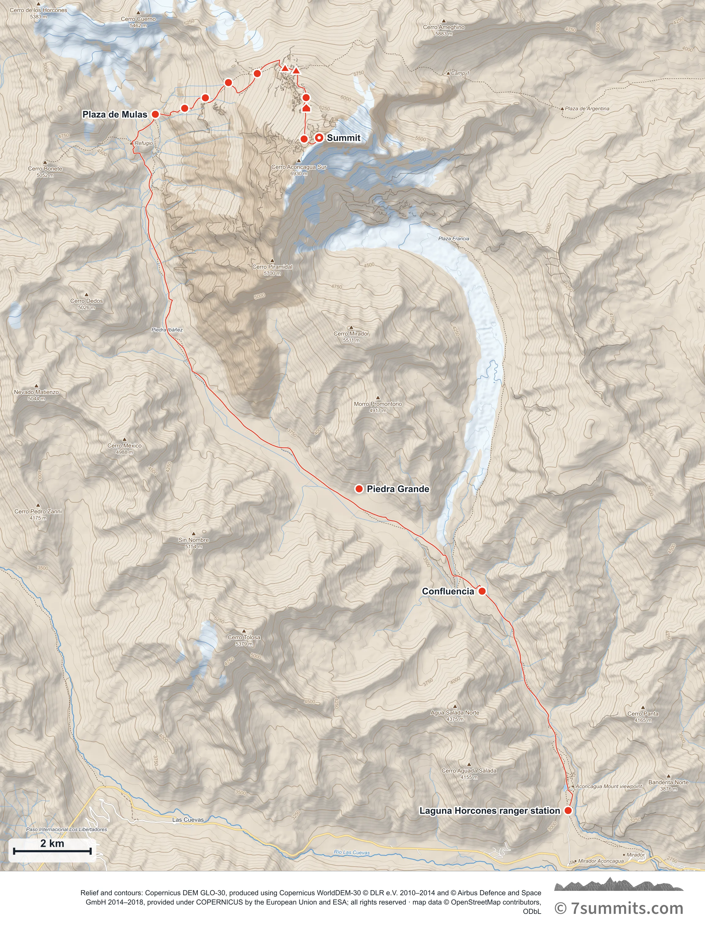
Point at the route or drag along the profile to see the height and the distance walked.
GPX files
Download the Normal Route track
Navigation aid only, not a substitute for your own judgement, current conditions or local knowledge. Elevations are modelled from open terrain data, not surveyed.
Sources, credits and licence
© OpenStreetMap contributors (ODbL). Licence: See source. Source data
Waypoints
WGS84 decimal degrees. Elevations are modelled from open terrain data (roughly 20–50 m low on snow and ice), not published camp altitudes: read them as approximate positions, not pitches.
| Waypoint | Latitude | Longitude | m | ft |
|---|---|---|---|---|
| Laguna Horcones ranger station (2,950 m) | -32.81090 | -69.94251 | 2,950 | 9,678 |
| Confluencia (3,400 m) | -32.75950 | -69.96651 | 3,400 | 11,155 |
| Piedra Grande (3,650 m) | -32.73550 | -70.00083 | 3,650 | 11,975 |
| Plaza de Mulas: base camp (4,350 m) | -32.64764 | -70.05770 | 4,350 | 14,272 |
| Piedras Conway (4,750 m) | -32.64624 | -70.04951 | 4,750 | 15,584 |
| Plaza Cañada (5,050 m) | -32.64378 | -70.04373 | 5,050 | 16,568 |
| Cambio de Pendiente (5,300 m) | -32.64020 | -70.03731 | 5,300 | 17,388 |
| Nido de Cóndores (5,570 m) | -32.63807 | -70.02926 | 5,570 | 18,274 |
| Berlín camp (5,930 m) | -32.63679 | -70.02150 | 5,930 | 19,455 |
| Camp Cólera / White Rocks (5,950 m) | -32.63737 | -70.01839 | 5,950 | 19,521 |
| Falso Polaco junction: broad bench (6,250 m) | -32.64372 | -70.01563 | 6,250 | 20,505 |
| Independencia hut (6,380 m) | -32.64619 | -70.01557 | 6,380 | 20,932 |
| La Cueva: foot of the Canaleta (6,650 m) | -32.65344 | -70.01619 | 6,650 | 21,818 |
| Summit (6,961 m) | -32.65313 | -70.01198 | 6,961 | 22,838 |
Links to other people’s recordings, hosted by them. Compare and cross-check: never assume any single line is safe.