








The quieter side of the mountain: the walk in from Punta de Vacas to Plaza Argentina and the high camps, then the Polish Traverse and the technical Polish Glacier finishes, and the descent.
The Vacas Valley is Aconcagua's other approach, a three-day walk in from the Punta de Vacas trailhead (2,400 m7,874 ft) through Pampa de Leñas and Casa de Piedra to Plaza Argentina base camp (4,200 m13,780 ft), on the far side of the mountain from the Horcones valley and the Normal Route. Two routes to the summit start here, and both share that approach: the Polish Traverse (Falso de los Polacos) and the Polish Glacier.
They part company above the high camps. The Polish Traverse crosses west below the glacier to Rocas Blancas (6,095 m19,997 ft) and joins the Normal Route for the last of the climb, technically easy ground, apart from some icy sections. The Polish Glacier proper is a serious ice route, ranging from 35° to 50° and steeper depending on conditions, and it is not a variation on the Traverse. The map, the elevation profile and the downloadable track below are the Polish Traverse; the Glacier is not drawn.
An ascent via Vacas costs more than one via Horcones, and a traverse (up one valley, down the other) is charged at the Vacas rate: see Aconcagua permits and costs. For the companies that run the Polish Traverse, see the Aconcagua operators.
In this section
Maps & profiles
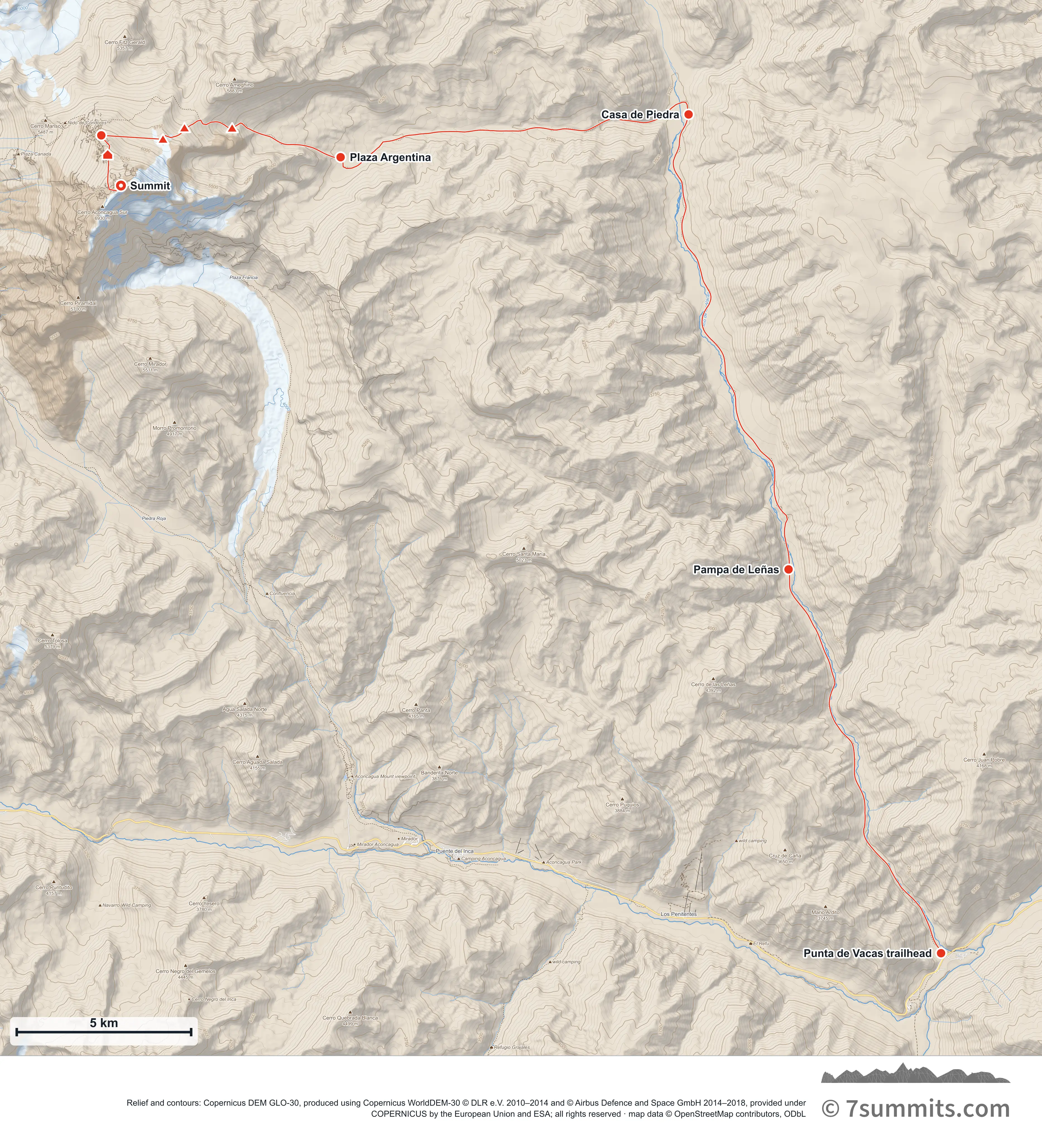
Point at the route or drag along the profile to see the height and the distance walked.
GPX files
Download the Polish Traverse track
CAMP POSITIONS ARE APPROXIMATE AND NOT FIXED. On a glacier there is no such thing as a permanent camp site: the ice is moving, and crevasses and snow bridges open, close and rot out between seasons and within a single season. A spot that was a safe, well-used camp one year can be dangerous the next, or later in the same year. These coordinates indicate roughly where camps are commonly sited: they are not an instruction to camp at a point. Always probe the area thoroughly yourself before making camp. Never treat a coordinate as evidence that ground is safe.
Navigation aid only, not a substitute for your own judgement, current conditions or local knowledge. Elevations are modelled from open terrain data, not surveyed.
Sources, credits and licence
© OpenStreetMap contributors (ODbL). Licence: See source. Source data
Waypoints
WGS84 decimal degrees. Elevations are modelled from open terrain data (roughly 20–50 m low on snow and ice), not published camp altitudes: read them as approximate positions, not pitches.
| Waypoint | Latitude | Longitude | m | ft |
|---|---|---|---|---|
| Punta de Vacas trailhead (2,400 m) | -32.85070 | -69.76088 | 2,400 | 7,874 |
| Pampa de Leñas (2,870 m) | -32.75198 | -69.80757 | 2,870 | 9,416 |
| Casa de Piedra (3,250 m) | -32.63480 | -69.83818 | 3,250 | 10,663 |
| Plaza Argentina: base camp (4,200 m) | -32.64582 | -69.94472 | 4,200 | 13,780 |
| Camp 1 (5,000 m) | -32.63833 | -69.97793 | 5,000 | 16,404 |
| Col Camp (5,550 m) | -32.63828 | -69.99252 | 5,550 | 18,209 |
| Camp 2 (5,850 m) | -32.64120 | -69.99911 | 5,850 | 19,193 |
| Rocas Blancas: White Rocks (6,095 m) | -32.64019 | -70.01799 | 6,095 | 19,997 |
| Independencia hut (6,390 m) | -32.64520 | -70.01603 | 6,390 | 20,965 |
| Summit (6,961 m) | -32.65313 | -70.01198 | 6,961 | 22,838 |
Links to other people’s recordings, hosted by them. Compare and cross-check: never assume any single line is safe.