Home › Elbrus › Elbrus map
Elbrus map Where Elbrus is, and each route we map on it with the camps marked. Every map opens larger, and each group links to the chapter that describes the route.
Where Elbrus is Where on Earth: Elbrus, one of the 7 summits. · Imagery: NASA Earth Observatory “Blue Marble” · borders: Natural Earth (public domain) Elbrus: Overview Elbrus within Europe. · Imagery: NASA Earth Observatory “Blue Marble” · borders: Natural Earth (public domain) Both routes on one map: the South route from Azau and the North route from Emanuel Glade, on opposite sides of the mountain. Navigation aid only, not for wayfinding. · © MapTiler © OpenStreetMap contributors Read the chapter: Elbrus: Overview
Choosing your route: South vs North Both routes on one mountain. The South route climbs the near flank from Azau; the North route comes over the far side from Emanuel Glade. They meet near the top, and both finish on the West summit, the highest point in Europe. · Elevation data © Copernicus DEM (GLO-30) · peak names © OpenStreetMap contributors Read the chapter: Choosing your route: South vs North
The South (Normal) route Point at the route or drag along the profile to see the height and the distance walked.
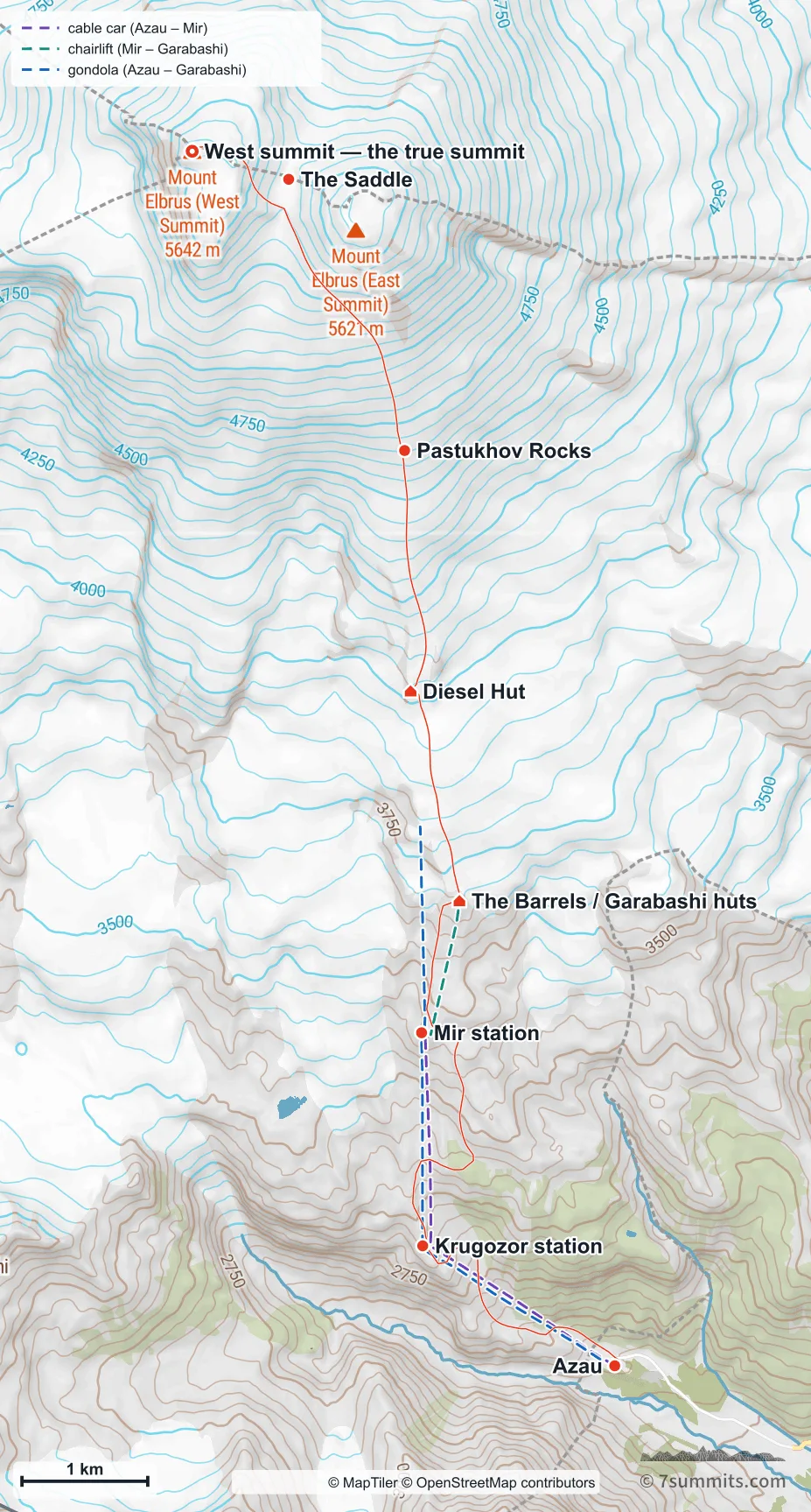
The South (Normal) route from Azau to the West summit, with the huts, the Pastukhov Rocks and the three aerial lifts marked. Most parties ride the lifts to the huts; the walking line below them is drawn because the lifts are often out of service. Navigation aid only, not for wayfinding. · © MapTiler © OpenStreetMap contributors The whole route seen from the south-east. The service road switchbacking up from Azau, and the rising traverse across the West summit’s flank above the Pastukhov Rocks, are what a map cannot show. · Elevation data © Copernicus DEM (GLO-30) · peak names © OpenStreetMap contributors Read the chapter: The South (Normal) route
Azau to the Barrels huts Azau to the Barrels on foot: the service road that doubles as a piste in winter, switchbacking up ground the cable cars cross in a straight line. · Elevation data © Copernicus DEM (GLO-30) · peak names © OpenStreetMap contributors Read the chapter: Azau to the Barrels huts
Summit day from the south Summit day from the south: past the Diesel Hut and the Pastukhov Rocks, then the long rising traverse that bends west below the saddle to the West summit. · Elevation data © Copernicus DEM (GLO-30) · peak names © OpenStreetMap contributors Read the chapter: Summit day from the south
The North route Point at the route or drag along the profile to see the height and the distance walked.
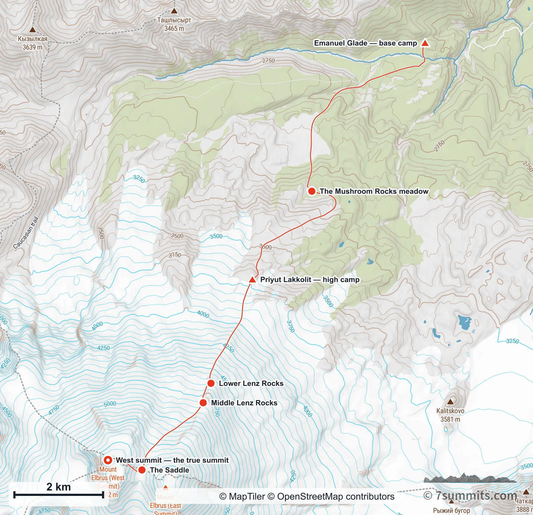
The North route from Emanuel Glade to the West summit, with the high camp and the Lenz Rocks marked. Navigation aid only, not for wayfinding. · © MapTiler © OpenStreetMap contributors The whole route seen from the north-east. The long walk in across the meadows, and the traverse to the saddle that leads to the West summit rather than the East, are what a map cannot show. · Elevation data © Copernicus DEM (GLO-30) · peak names © OpenStreetMap contributors Read the chapter: The North route
Emanuel Glade and base camp Emanuel Glade to the high camp: the meadows, the Mushroom Rocks, and the long eastward curve the trail takes to keep the angle reasonable. · Elevation data © Copernicus DEM (GLO-30) · peak names © OpenStreetMap contributors Read the chapter: Emanuel Glade and base camp
Summit day from the north Summit day from the north: up the Lenz Rocks, then the traverse west to the saddle and the climb to the West summit. Continuing up the rib instead reaches the East summit: shorter, but not the highest point. · Elevation data © Copernicus DEM (GLO-30) · peak names © OpenStreetMap contributors Read the chapter: Summit day from the north
Using these maps 7summits.com draws these maps from GPS tracks and open elevation data, and each one carries the credit its sources ask for. To use one in print or on another site, ask us first. Get in touch