








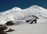

The big day: a pre-dawn start (on foot or by snowcat), up past the Pastukhov Rocks, across below the East summit to the saddle at ~5,350 m, and the final slope to the West summit at 5,642 m.
| Time (up) | roughly 6–9 hours on foot from the huts, less from a snowcat drop-off; a long day both ways |
| Altitude gained | ~1,850 m6,070 ft on foot: huts 3,800 m12,467 ft → West summit 5,642 m18,510 ft (much less if you take the snowcat to ~5,000 m16,404 ft) |
| Terrain | long glacier slopes, a traverse below the East summit, the saddle, and a steep final pitch; crampons, roped, ice axe |
| Grade | non-technical but long, high, cold and exposed, the crux is the altitude and the weather |
| Summary | A pre-dawn start to the saddle and up to the West summit (5,642 m18,510 ft), then all the way back down the same day. |
This is where Elbrus kills people, and almost never through hard climbing. The upper mountain is a featureless white plateau; in cloud or a whiteout climbers lose the descent and get lost between the two summits, and the cold and altitude do the rest. Agree a turnaround time and keep it, make sure you can navigate down blind, and turn back when the weather turns. Re-read Health and safety before you go up.
Summit day starts in the small hours (often around one or two in the morning) so that you reach the top and get back down before the afternoon weather builds. You climb by headlamp, in the cold, and the first decision has usually been made the night before: whether to climb the whole way on foot or take a snowcat.
On foot or by snowcat
If you climb from the huts you start at about 3,800 m12,467 ft and grind up the glacier past the Pastukhov Rocks, a long, honest bottom half to the day. If you pay for a snowcat, it carries you in the dark to about 5,000 m16,404 ft and you start from there: hours shorter, far less climbing, but dropped straight into thin air with less on your feet, and it is fair to ask whether it is the climb you came for. Neither is wrong; just decide deliberately, with your guide, before summit morning. Full detail of the trade-off is on Lifts, snowcats and huts.
The traverse and the saddle
Above the Pastukhov Rocks the route climbs to the foot of the East summit, then makes a long, gradually rising traverse across its western flank (a stretch that feels endless in the dark and the cold) to reach the saddle, the wind-scoured dip between the two peaks at roughly 5,350 m17,552 ft. This traverse is where people get into trouble in bad weather. It is exposed and featureless, and you must find the same ground again on the way down. Fixed ropes are sometimes in place on the steeper sections; your guide will know.
Nothing is loaded from YouTube until you press play.
Filmed climbing from the Pastukhov Rocks past sunrise, over the traverse below the East summit, down into the saddle and up again through a short rock band to the summit plateau.
The final slope
From the saddle a steep final slope climbs to the summit plateau, then a short walk across it to the true high point of the West summit at 5,642 m18,510 ft. Depending on conditions there may be a fixed rope on the steep pitch out of the saddle. Then you are on top of Europe, but only halfway through the day. Which summit is which, and why the East top is a separate objective, is covered on The two summits and the traverse.
The descent
You descend the way you came, down the final slope, back across the traverse, past the Pastukhov Rocks to the huts, and you can carry on down the lifts to the valley the same day if you want a proper night's sleep and a shower. The descent is when tired people make mistakes and when the weather has often turned, so keep concentrating: most Elbrus accidents happen on the way down, not the way up.
Maps & profiles
Image credits: © SKas · CC BY-SA 4.0 · Wikimedia Commons · modified