








The south side, stage by stage: the trek in through Tengboche to Base Camp, the Khumbu Icefall and Western Cwm to the high camps, the Lhotse Face and South Col, summit day, and the descent.
The approach from Nepal is very different from the Tibet side, in culture as well as nature: there is no road, so you trek in (at least a week, for proper acclimatization) through the Khumbu valley, one long string of villages, teahouses and lodges where you can stop wherever you like. There are no roads and no motorised traffic, and you can hardly get lost.
In Nepal you start the actual climb much closer to the mountain, so the climbing route is much shorter: as the crow flies, Nepal BC is about as far from the summit as Tibet ABC, which itself is only some 6 km from Nepal BC. The route is easy to find: you follow the fixed lines from BC through the Khumbu Icefall, cross the Western Cwm, and then follow the ropes to the summit. As on any high mountain, you climb most sections two, three or even four times while acclimatizing; we describe each section only once.
The eight stages below follow the expedition in order: the spectacular flight to Lukla and the week-long teahouse trek through the Khumbu valley, the dangerous Icefall crossing, the furnace of the Western Cwm, the hard ice of the Lhotse Face, the climb to the South Col, summit day over the Cornice Traverse and the Hillary Step, and the descent and trek out. Each climbing stage opens with a box summarizing altitude gained, typical times up and down, and the character of the terrain.
In this section
Maps & profiles
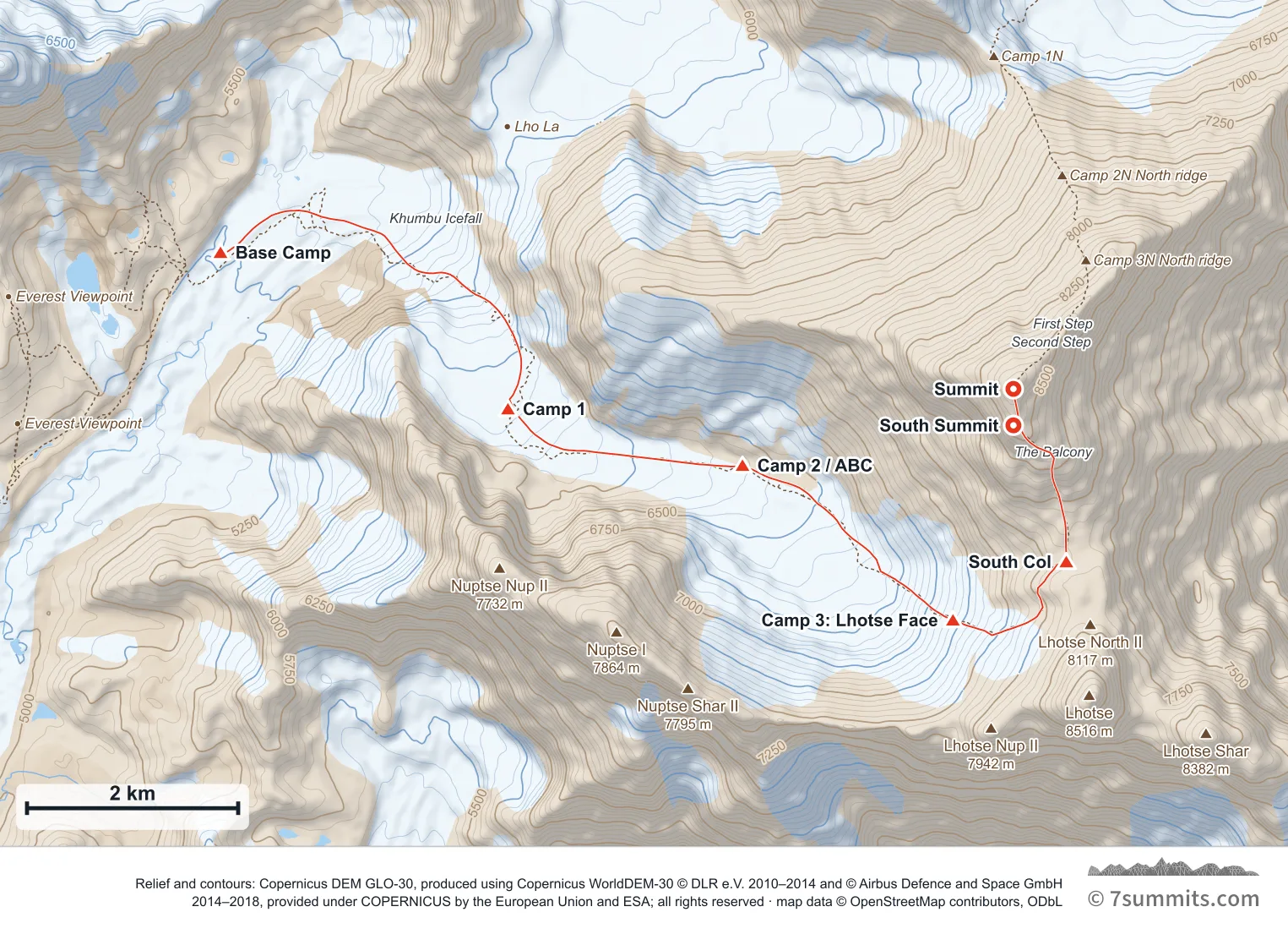
Point at the route or drag along the profile to see the height and the distance walked.
GPX files
Download the South Col / SE Ridge track
CAMP POSITIONS ARE APPROXIMATE AND NOT FIXED. On a glacier there is no such thing as a permanent camp site: the ice is moving, and crevasses and snow bridges open, close and rot out between seasons and within a single season. A spot that was a safe, well-used camp one year can be dangerous the next, or later in the same year. These coordinates indicate roughly where camps are commonly sited: they are not an instruction to camp at a point. Always probe the area thoroughly yourself before making camp. Never treat a coordinate as evidence that ground is safe.
Navigation aid only, not a substitute for your own judgement, current conditions or local knowledge. Elevations are modelled from open terrain data, not surveyed.
Sources, credits and licence
© OpenStreetMap contributors (ODbL). Licence: See source. Source data
Waypoints
WGS84 decimal degrees. Elevations are modelled from open terrain data (roughly 20–50 m low on snow and ice), not published camp altitudes: read them as approximate positions, not pitches.
| Waypoint | Latitude | Longitude | m | ft |
|---|---|---|---|---|
| Base Camp (17,598 ft) | 27.99970 | 86.84880 | 5,364 | 17,598 |
| Camp 1 (19,882 ft) | 27.98640 | 86.87650 | 6,060 | 19,882 |
| Camp 2 / ABC (20,997 ft) | 27.98160 | 86.89910 | 6,400 | 20,997 |
| Camp 3: Lhotse Face (23,622 ft) | 27.96845 | 86.91937 | 7,200 | 23,622 |
| South Col (Camp 4) (25,984 ft) | 27.97340 | 86.93030 | 7,920 | 25,984 |
| South Summit (28,704 ft) | 27.98500 | 86.92520 | 8,749 | 28,704 |
| Summit (29,032 ft) | 27.98810 | 86.92520 | 8,849 | 29,032 |
Links to other people’s recordings, hosted by them. Compare and cross-check: never assume any single line is safe.