









The north side, stage by stage: the journey in to Base Camp, the trek up to Advanced Base Camp, the North Col and the camps above it, the final ridge to the summit, and the descent.
For the 2026 season China closed the Tibetan side of Everest (with Cho Oyu and Shishapangma) to foreign climbers, after a scandal over a fireworks display near Shigatse in September 2025, and no reopening date had been announced when this page was last checked in October 2026. Check with your operator before planning a Tibet-side expedition.
The route from the Tibetan side of Everest is interesting in many ways: you get to see a little of Tibetan and Chinese culture as well as the mountain. As with any high mountain, you will climb many sections two, three or even four times, ascending to acclimatize and descending again to rest. Every time you will go a lot faster, so the timings given are flexible, we describe each section only once; discuss your exact itinerary with your team leaders.
Even within the route there are variations, for example in where to put the camps: we describe the main stretches one section each, and mention intermediate camps and other options. The upper climbing route itself is easy to find (you basically follow the fixed line from just above ABC to the summit) so the chapters focus less on route-finding and more on the specific conditions found on the way.
The nine stages below follow the expedition in order: the drive in from Kathmandu over the Tibetan plateau, the two-day yak trek up the East Rongbuk Glacier to Advanced Base Camp, the snow and ice climb to the North Col, the camps on the North Ridge, the long summit day with its three famous rock Steps, what to do on the summit itself, and the descent and journey home. Each stage page opens with a box summarizing altitude gained, typical times up and down, and the character of the terrain.
In this section
Maps & profiles
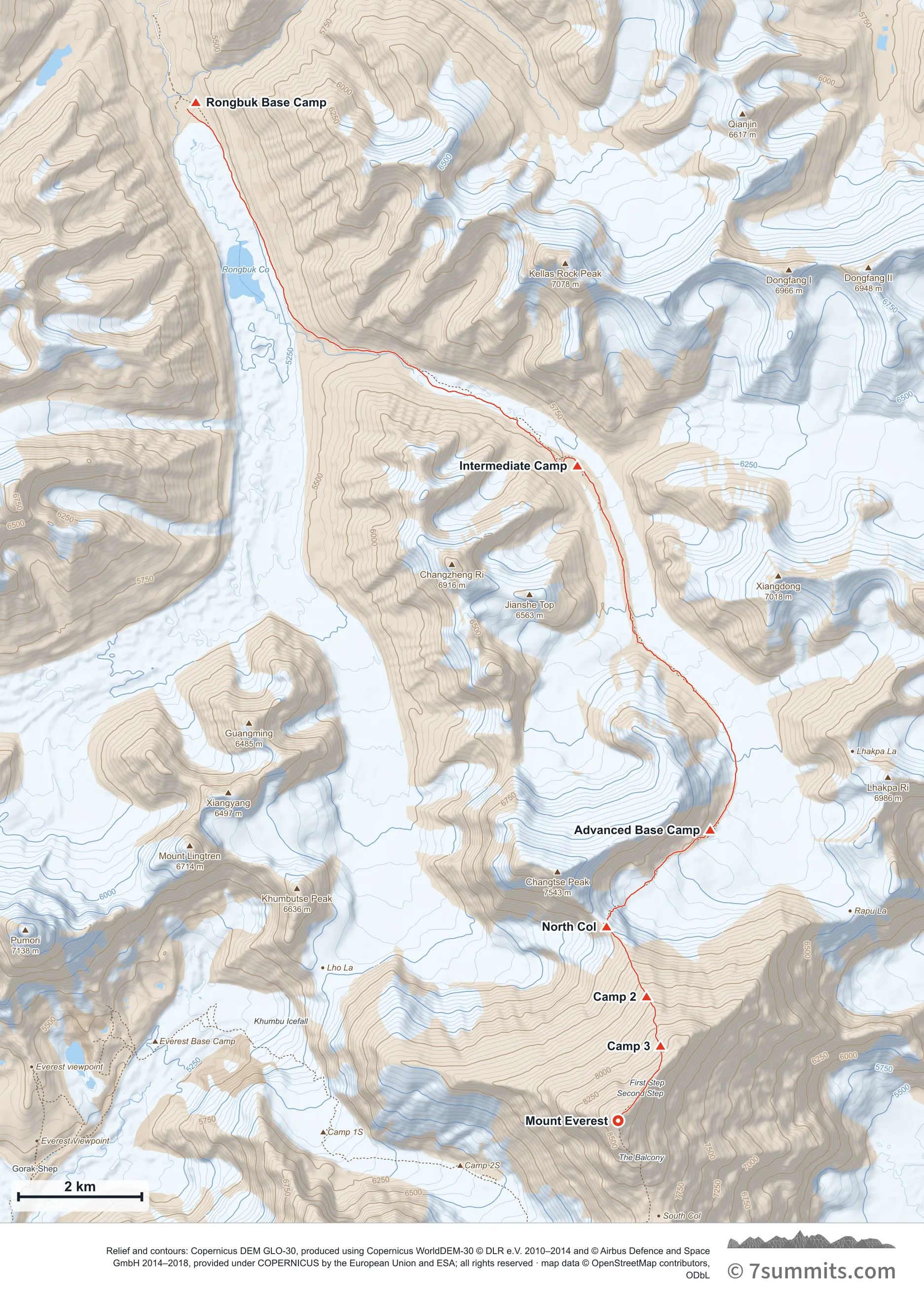
Point at the route or drag along the profile to see the height and the distance walked.
GPX files
Download the North Col / NE Ridge track
CAMP POSITIONS ARE APPROXIMATE AND NOT FIXED. On a glacier there is no such thing as a permanent camp site: the ice is moving, and crevasses and snow bridges open, close and rot out between seasons and within a single season. A spot that was a safe, well-used camp one year can be dangerous the next, or later in the same year. These coordinates indicate roughly where camps are commonly sited: they are not an instruction to camp at a point. Always probe the area thoroughly yourself before making camp. Never treat a coordinate as evidence that ground is safe.
Navigation aid only, not a substitute for your own judgement, current conditions or local knowledge. Elevations are modelled from open terrain data, not surveyed.
Sources, credits and licence
Derived from public recorded GPS tracks: Adrian Ballinger, "Lunch Hike" — Base Camp to Advanced Base Camp — strava.com/…/14627823109 ; Adrian Ballinger, "Everest Summit on a perfect day (C2-Summit-ABC). I like skipping camps" — strava.com/…/14627821228 ; Griffin Mims, "Solo hike down from ABC" — Advanced Base Camp to Base Camp — strava.com/…/14478056690 ; Griffin Mims, "I just climbed Mount Everest" — strava.com/…/14627937234 ; Adrian Ballinger, "Everest Summit — no supplementary oxygen", 27 May 2017 — strava.com/…/1010919986 ; Adrian Ballinger, "Morning run" — Base Camp to Advanced Base Camp — strava.com/…/1027479069 ; Cory Richards, "Night Hike" — Advanced Base Camp to the summit — strava.com/…/1012992233 ; Cory Richards, "Morning Hike" — Base Camp to Advanced Base Camp — strava.com/…/1013004967 ; Mark van 't Hof, "Ochtendloop" — Advanced Base Camp to Base Camp — strava.com/…/1014233079 ; Mike Lutz, "BC to IBC" — strava.com/…/1585731545 ; Mike Lutz, "IBC to ABC" — strava.com/…/1585732038 ; Mike Lutz, "ABC to North Col" — strava.com/…/1585766151 ; Mike Lutz, "North Col to Camp 2" — strava.com/…/1585910847 ; Mike Lutz, "Camp 2 to Camp 3" — strava.com/…/1585913767 ; Mike Lutz, "Summit day — Camp 3, summit, down to ABC" — strava.com/…/1585966960 ; Mike Lutz, "ABC to BC" — strava.com/…/1585969441 ; Alexei Bakulin, "Утренний забег" — the East Rongbuk approach — strava.com/…/1559864811 ; Alexei Bakulin, "Утренний забег" — Advanced Base Camp to the North Col — strava.com/…/1559871851 ; Benoît Clerc, "ABC down to BC" — strava.com/…/2342855322 ; Caroline Gleich, "Base camp to IC — will we summit? I hope weather holds" — strava.com/…/2376949631 ; Caroline Gleich, "Interim camp to ABC at 21,000 ft (6,350 m)" — strava.com/…/2376955756 ; Caroline Gleich, "Advanced base camp — back to base camp" — strava.com/…/2355929915 ; Caroline Gleich, "Morning Run" — strava.com/…/2398265784 ; Caroline Gleich, "Everest ABC to BC — back off the mtn" — strava.com/…/2398304057. Elevation data © Mapzen Terrain Tiles, sourced from USGS, NASA SRTM/ASTER and NOAA.. Licence: Derived work — sources credited individually. Source data
Waypoints
WGS84 decimal degrees. Elevations are modelled from open terrain data (roughly 20–50 m low on snow and ice), not published camp altitudes: read them as approximate positions, not pitches.
| Waypoint | Latitude | Longitude | m | ft |
|---|---|---|---|---|
| Rongbuk Base Camp (17,060 ft) | 28.13650 | 86.85550 | 5,200 | 17,060 |
| Intermediate Camp (19,029 ft) | 28.08357 | 86.91848 | 5,800 | 19,029 |
| Advanced Base Camp (21,325 ft) | 28.03050 | 86.94040 | 6,500 | 21,325 |
| North Col (Camp 1) (23,058 ft) | 28.01640 | 86.92330 | 7,028 | 23,058 |
| Camp 2 (25,558 ft) | 28.00620 | 86.92990 | 7,790 | 25,558 |
| Camp 3 (27,231 ft) | 27.99900 | 86.93220 | 8,300 | 27,231 |
| Mount Everest (29,032 ft) | 27.98810 | 86.92520 | 8,849 | 29,032 |
Links to other people’s recordings, hosted by them. Compare and cross-check: never assume any single line is safe.