








The Northern Circuit
The longest route on Kilimanjaro and the best for acclimatization, looping almost all the way around the mountain through its quiet northern slopes. The strongest choice for reaching the summit.
The Northern Circuit is the longest route on Kilimanjaro and the newest, and it has quickly become the choice for people who want the best possible chance of reaching the top. It starts on the western side, the same way as Lemosho, but instead of turning up onto the southern circuit it swings north and makes a long loop around the quiet, remote northern slopes of the mountain (the side hardly anyone else walks) before coming round to summit from the east. In the course of the climb you see almost the whole mountain, close to a full circle of it.
Its great strength is time. At around nine days on the mountain it gives your body more days and more gradual height gain than any other route, which is exactly what acclimatization needs. It is also the quietest of the popular routes once it leaves the Lemosho trail, and a camping route throughout. If your priority is acclimatization and solitude, this is the route we would point you to first.
This section describes only the Northern Circuit’s own stages, the northern loop from the Shira Plateau round to School Hut. The route shares its first days with Lemosho (the drive to Londorossi, the forest walk to Mti Mkubwa, and the climb to Shira 1), and it shares its summit day with the eastern routes (via Gilman’s Point) and its descent with the southern routes (via Mweka). Those shared stages are linked from the pages here rather than repeated.
In this section
Maps & profiles
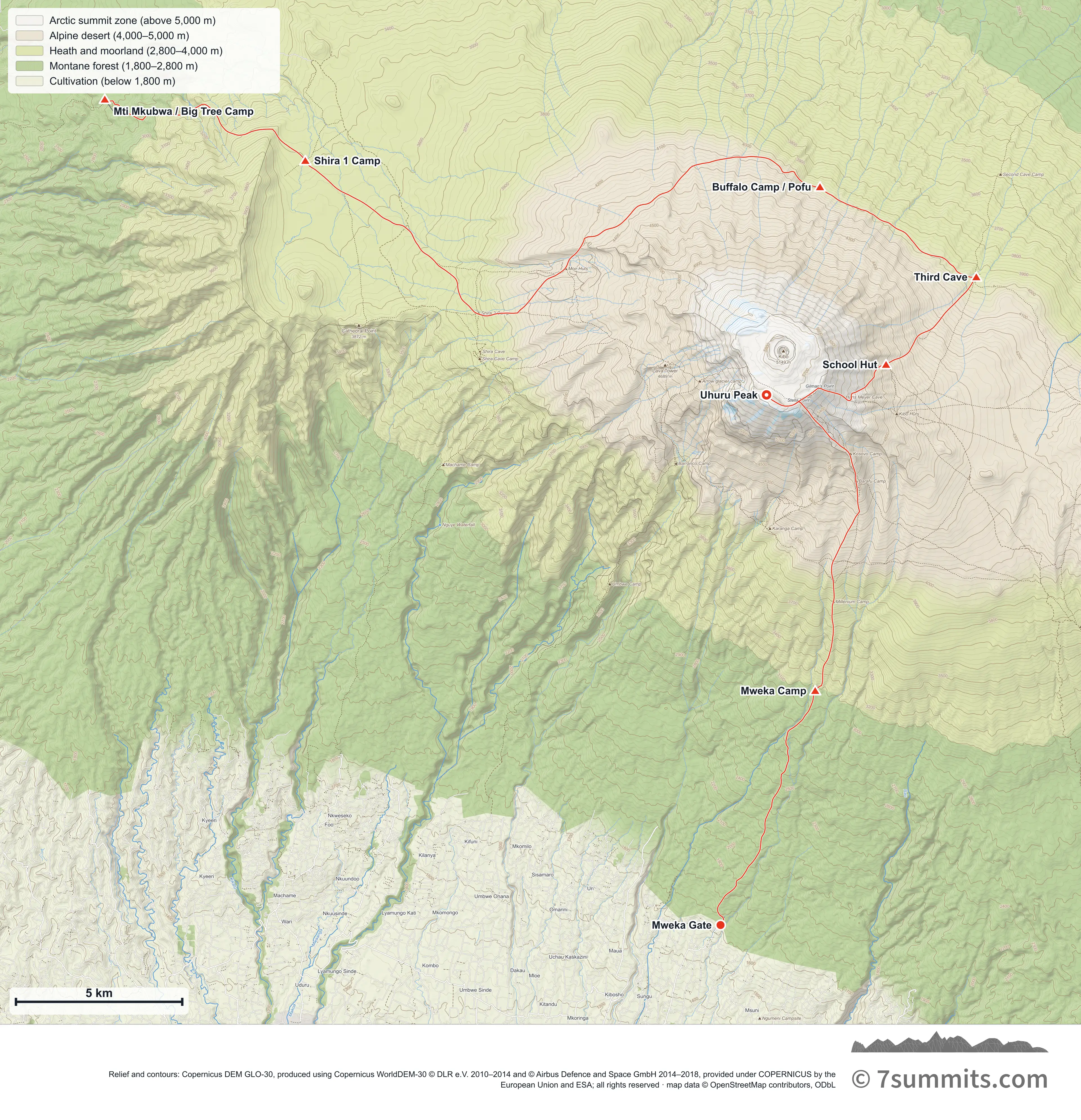
Point at the route or drag along the profile to see the height and the distance walked.
GPX files
Download the Northern Circuit track
Navigation aid only, not a substitute for your own judgement, current conditions or local knowledge. Elevations are modelled from open terrain data, not surveyed.
Sources, credits and licence
© OpenStreetMap contributors (ODbL). Licence: See source. Source data
Waypoints
WGS84 decimal degrees. Elevations are modelled from open terrain data (roughly 20–50 m low on snow and ice), not published camp altitudes: read them as approximate positions, not pitches.
| Waypoint | Latitude | Longitude | m | ft |
|---|---|---|---|---|
| Mti Mkubwa / Big Tree Camp (9,022 ft) | -2.99657 | 37.17500 | 2,750 | 9,022 |
| Shira 1 Camp (11,483 ft) | -3.01314 | 37.22924 | 3,500 | 11,483 |
| Moir Hut (13,648 ft) | -3.04232 | 37.29974 | 4,160 | 13,648 |
| Buffalo Camp / Pofu (13,123 ft) | -3.02024 | 37.36846 | 4,000 | 13,123 |
| Third Cave (12,467 ft) | -3.04456 | 37.41075 | 3,800 | 12,467 |
| School Hut (15,748 ft) | -3.06821 | 37.38633 | 4,800 | 15,748 |
| Uhuru Peak (19,341 ft) | -3.07641 | 37.35400 | 5,895 | 19,341 |
| Mweka Camp (10,171 ft) | -3.15626 | 37.36717 | 3,100 | 10,171 |
| Mweka Gate (5,381 ft) | -3.21954 | 37.34156 | 1,640 | 5,381 |
Links to other people’s recordings, hosted by them. Compare and cross-check: never assume any single line is safe.