








Kilimanjaro’s neighbour: a tough, beautiful four-day volcano climb to 4,562 m that is the best possible acclimatization before Kilimanjaro.
Mount Meru is the mountain most people flying into Kilimanjaro never notice, and it deserves better. It stands about 70 km west of Kilimanjaro, right beside Arusha, a dramatic 4,562 m14,967 ft volcano with a great horseshoe-shaped crater blown open on one side and a perfect ash cone rising inside it. It is the second-highest mountain in Tanzania, and on a clear morning from its summit you look east to see Kilimanjaro floating above the clouds.
Nothing is loaded from YouTube until you press play.
A short overview of Meru's climb, including the dramatic walk along the crater rim's knife edge, gives a sense of the exposed ridge scrambling near the summit.
For climbers, Meru’s real value is as acclimatization. It is a proper mountain climb (tougher, steeper and more exposed than Kilimanjaro’s walk-up, with a narrow, airy summit ridge) but it tops out well below Kilimanjaro, so climbing it first, with a rest day or two in between, is the best possible preparation for the big mountain. It is close to the only sensible way to do one of the shorter Kilimanjaro routes safely. Even on its own it is a wonderful climb, quiet and wild, and far less crowded than Kilimanjaro.
There is a single route up Meru, through Arusha National Park, and because the lower slopes are full of game (buffalo, elephant, giraffe and more) an armed park ranger is required to walk with every group. This section covers the logistics and cost, and then the climb day by day: the walk in to Miriakamba, the steep climb to Saddle Hut with an afternoon hike up Little Meru, the long summit day along the crater rim to Socialist Peak, and the descent.
In this section
Maps & profiles
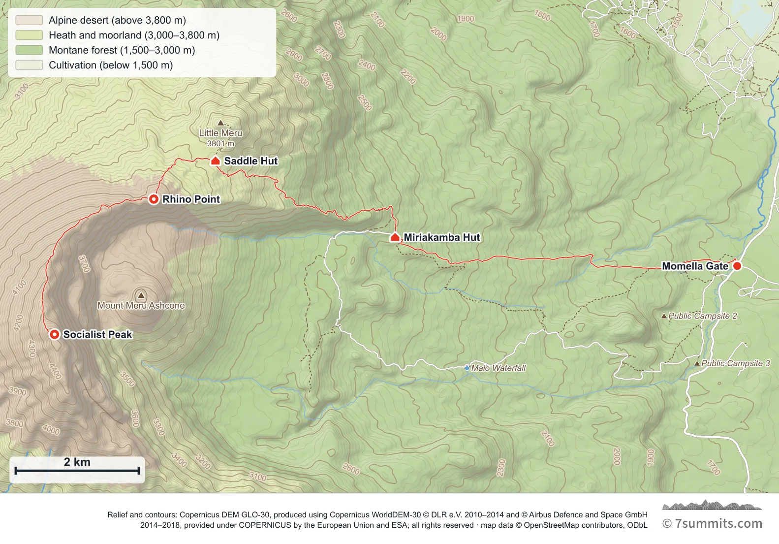
Point at the route or drag along the profile to see the height and the distance walked.
GPX files
Download the Mount Meru track
Navigation aid only, not a substitute for your own judgement, current conditions or local knowledge. Elevations are modelled from open terrain data, not surveyed.
Sources, credits and licence
Derived from public recorded GPS tracks: Anonymous (Strava export), "Mt Meru" — Momella Gate to Socialist Peak and back, 21 August 2024 ; goyastua, "Meru peak" — Momella Gate to the saddle and back, 20 January 2024 — wikiloc.com/…/meru-peak-158609694 ; lamorosangel, "Etapa 1 · Trek del Volcán Meru · De Momella Gate a Miriakamba Hut" — wikiloc.com/…/etapa-1-trek-del-volcan-meru-de-momella-gate-a-miriakamba-hut-tanzania-179368462 ; lamorosangel, "Etapa 4 · Trek del Volcán Meru · De Miriakamba Hut a Momella Gate" — the same trek walking out — wikiloc.com/…/etapa-4-trek-del-volcan-meru-de-miriakamba-hut-a-momella-gate-tanzania-179368544 ; jisna jb, "Mt Meru, Tanzania (Full Loop)" — the three-day trek, 16-18 July 2023 — wikiloc.com/…/mt-meru-tanzania-140966891 ; Thadey Michael, "Mount Meru" — Saddle Hut to the summit and down to the gate, 20 December 2024 — wikiloc.com/…/mount-meru-195305502. Elevation data © Mapzen Terrain Tiles, sourced from USGS, NASA SRTM/ASTER and NOAA.. Licence: Derived work — sources credited individually. Source data
Waypoints
WGS84 decimal degrees. Elevations are modelled from open terrain data (roughly 20–50 m low on snow and ice), not published camp altitudes: read them as approximate positions, not pitches.
| Waypoint | Latitude | Longitude | m | ft |
|---|---|---|---|---|
| Momella Gate (1,585 m) | -3.23345 | 36.84964 | 1,585 | 5,200 |
| Miriakamba Hut (2,514 m) | -3.22926 | 36.79960 | 2,514 | 8,248 |
| Saddle Hut (3,570 m) | -3.21810 | 36.77332 | 3,570 | 11,713 |
| Rhino Point (3,800 m) | -3.22369 | 36.76430 | 3,800 | 12,467 |
| Socialist Peak (4,562 m) | -3.24343 | 36.74979 | 4,562 | 14,967 |
Links to other people’s recordings, hosted by them. Compare and cross-check: never assume any single line is safe.
- goyastua, "Meru peak" on Wikiloc — Momella Gate to the saddle and back, January 2024
- lamorosangel, "Etapa 1 · De Momella Gate a Miriakamba Hut" on Wikiloc — the walk in
- lamorosangel, "Etapa 4 · De Miriakamba Hut a Momella Gate" on Wikiloc — the same trek walking out
- Thadey Michael, "Mount Meru" on Wikiloc — the summit push and the descent
- jisna jb, "Mt Meru, Tanzania (Full Loop)" on Wikiloc — the three-day trek, which covers the route above Miriakamba