GuidebooksThe listsOperatorsForumGearLibraryNews
Search

Guidebooks

  • Everest8,849 m
  • Aconcagua6,961 m
  • Denali6,190 m
  • Kilimanjaro5,895 m
  • Elbrus5,642 m
  • Vinson4,892 m
  • Carstensz Pyramid4,884 m
  • Kosciuszko2,228 m

  • Offline expedition packs
  • Statistics
  • Trip reports

The lists

  • The 7 summits›
  • All finishers798
  • Kosciuszko list453also the Bass list
  • Carstensz list558also the Messner list
  • 8 Summits248both
  • Apply for the list

  • Bass vs. Messner
  • Leaderboards
  • Women
  • Men

Operators

  • DirectoryEvery 7summits company
  • Compare operatorsSide by side, and what to ask

For companies

  • Add your company
  • Claim your listing
  • Become a partner

Forum

  • Forum home
  • The 7 summits›
  • Planning your climb›
  • Gear›
  • The community›
  • Members' lounge›

  • Leaderboard
  • Community guidelines

Gear

  • All gear
  • My gear shed
  • My trip duffels

Gear lists

  • Everest
  • Aconcagua
  • Denali
  • Kilimanjaro
  • Elbrus
  • Vinson
  • Carstensz
  • Kosciuszko

Library

  • Books & films
  • FAQ
  • Climbing glossary
  • Trivia quiz
  • QuotesInspiration

Featured

Book of the WeekSeven SummitsDick BassView in the Library →

News & Blog

  • All posts
  • News
  • Series

7summits.com

  • About us
  • Membership
  • Roadmap
  • Support us
  • Contact

7summits.com

Authoritative guides, the world's best finisher database, and community, for everyone who dreams of the 7 summits.

Support 7summits

Explore

  • Guidebooks
  • Library
  • Finishers
  • Finisher badge
  • FAQ
  • 7summits hub
  • Operators
  • Membership
  • Supporters
  • About
  • Partner with us
  • Roadmap
  • Quotes

Legal

  • Privacy
  • Disclaimer
  • Terms & Conditions
  • Community guidelines
  • Contact
© 2026 7summits.comAffiliate disclosure ↗
Home › Kosciuszko › Kosciuszko map

Kosciuszko map

Where Kosciuszko is, and each route we map on it with the camps marked. Every map opens larger, and each group links to the chapter that describes the route.

Where Kosciuszko is

Where on Earth: Kosciuszko, one of the 7 summits. · Imagery: NASA Earth Observatory “Blue Marble” · borders: Natural Earth (public domain)

Kosciuszko: Overview

Kosciuszko within Australia. · Imagery: NASA Earth Observatory “Blue Marble” · borders: Natural Earth (public domain)

Read the chapter: Kosciuszko: Overview

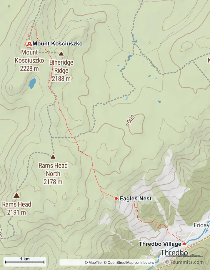
The Thredbo chairlift

Topographic map of the Merritts Nature Track on Mount Kosciuszko, climbing on foot from Thredbo village to Eagles Nest and continuing along the Summit Walk to the summit

Point at the route or drag along the profile to see the height and the distance walked.

The Merritts Nature Track: Thredbo village to Eagles Nest on foot, then the Summit Walk to the top. This is the route when the chairlift is not running, and it adds about 560 m of climbing. Navigation aid only, not for wayfinding. · © MapTiler © OpenStreetMap contributors

Read the chapter: The Thredbo chairlift

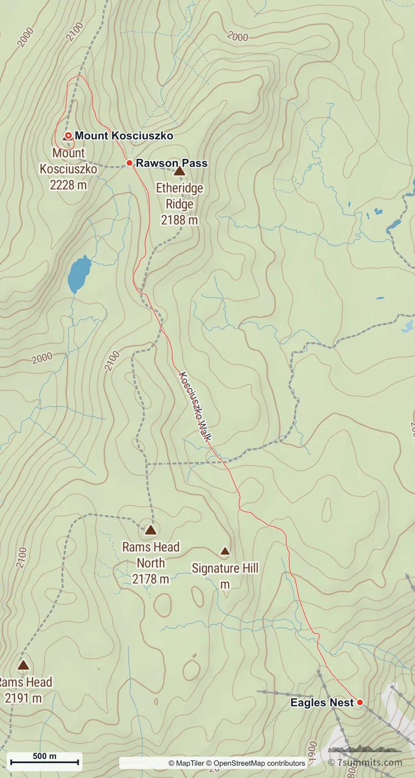
The Thredbo summit walk

Topographic map of the Thredbo Summit Walk on Mount Kosciuszko, from the top of the Kosciuszko Express chairlift at Eagles Nest past Kosciuszko Lookout and Rawson Pass to the summit

Point at the route or drag along the profile to see the height and the distance walked.

The Summit Walk from the top of the Thredbo chairlift at Eagles Nest to the summit, on the raised metal walkway most of the way. Navigation aid only, not for wayfinding. · © MapTiler © OpenStreetMap contributors

Read the chapter: The Thredbo summit walk

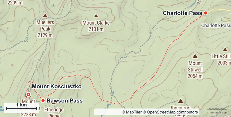
The Charlotte Pass summit walk

Topographic map of the Charlotte Pass Summit Walk on Mount Kosciuszko, from Charlotte Pass along the old summit road past Rawson Pass to the summit

Point at the route or drag along the profile to see the height and the distance walked.

The Summit Walk from Charlotte Pass, following the old summit road to Rawson Pass and the summit. Navigation aid only, not for wayfinding. · © MapTiler © OpenStreetMap contributors

Read the chapter: The Charlotte Pass summit walk

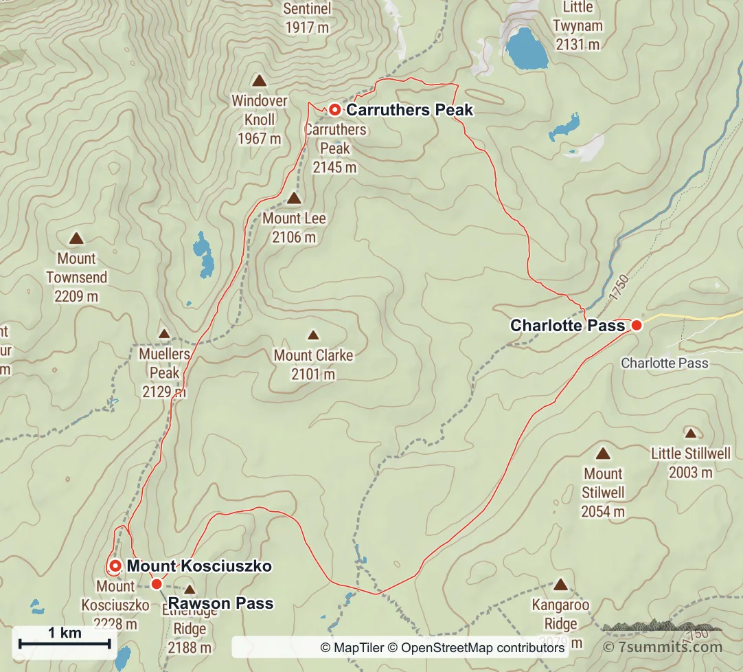
The Main Range loop

Topographic map of the Main Range loop on Mount Kosciuszko, anticlockwise from Charlotte Pass north past Blue Lake to Carruthers Peak, south along the Main Range to the summit spur, up to the summit and back to Rawson Pass, then out along the old summit road to Charlotte Pass

Point at the route or drag along the profile to see the height and the distance walked.

The Main Range loop from Charlotte Pass: north past the glacial lakes to Carruthers Peak, along the range to the summit, and back on the old summit road. The stretch between Rawson Pass and the summit is walked twice, once in each direction. Navigation aid only, not for wayfinding. · © MapTiler © OpenStreetMap contributors

Read the chapter: The Main Range loop

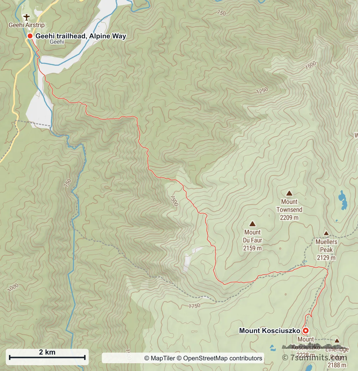
Hannels Spur

Topographic map of Hannels Spur on Mount Kosciuszko, from Geehi on the Alpine Way climbing steeply east across the Main Range to the summit

Point at the route or drag along the profile to see the height and the distance walked.

Hannels Spur from Geehi on the Alpine Way to the summit: about 1,790 m of ascent, one of the largest continuous climbs in Australia. Navigation aid only, not for wayfinding. · © MapTiler © OpenStreetMap contributors

Read the chapter: Hannels Spur

Using these maps

7summits.com draws these maps from GPS tracks and open elevation data, and each one carries the credit its sources ask for. To use one in print or on another site, ask us first. Get in touch

Plan this climb

See the operators who guide this peak, and what each trip includes.

Find an operator

Run expeditions, or make something climbers rely on?

Partner with us →

From the library

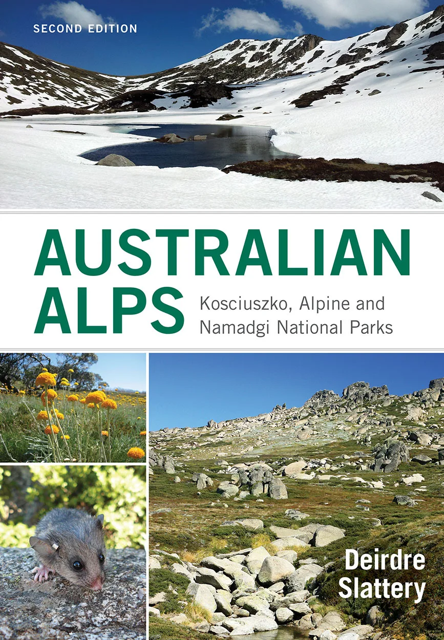
Australian Alps [OP]: Kosciuszko, Alpine and Namadgi National ParksDeirdre SlatteryFor Kosciuszko

See detailsGo to the library

Book of the Week

Seven SummitsDick Bass

See detailsGo to the library

Support 7summits

This site is kept going by its readers. Give once, any amount.

Support us

Finished the 7?

Apply to be listed
Share this page
EmailWhatsApp

Spotted something? Help us make this page better.

  • Correction or missing information
  • Photo, GPX or file
  • Something else

The 7 summits mailing list

Sign up for the 7 summits mailing list (7 summits news, operator info, regulations & permits, gear, site updates and more)

Nothing is sent until you confirm. Every mailing has a one-click unsubscribe link.

GuidebooksThe listsOperatorsForumGearLibraryNews
Search

Guidebooks

  • Everest8,849 m
  • Aconcagua6,961 m
  • Denali6,190 m
  • Kilimanjaro5,895 m
  • Elbrus5,642 m
  • Vinson4,892 m
  • Carstensz Pyramid4,884 m
  • Kosciuszko2,228 m

  • Offline expedition packs
  • Statistics
  • Trip reports

The lists

  • The 7 summits›
  • All finishers798
  • Kosciuszko list453also the Bass list
  • Carstensz list558also the Messner list
  • 8 Summits248both
  • Apply for the list

  • Bass vs. Messner
  • Leaderboards
  • Women
  • Men

Operators

  • DirectoryEvery 7summits company
  • Compare operatorsSide by side, and what to ask

For companies

  • Add your company
  • Claim your listing
  • Become a partner

Forum

  • Forum home
  • The 7 summits›
  • Planning your climb›
  • Gear›
  • The community›
  • Members' lounge›

  • Leaderboard
  • Community guidelines

Gear

  • All gear

Gear lists

  • Everest
  • Aconcagua
  • Denali
  • Kilimanjaro
  • Elbrus
  • Vinson
  • Carstensz
  • Kosciuszko

Library

  • Books & films
  • FAQ
  • Climbing glossary
  • Trivia quiz
  • QuotesInspiration

Featured

Book of the WeekSeven SummitsDick BassView in the Library →

News & Blog

  • All posts
  • News
  • Series

7summits.com

  • About us
  • Membership
  • Roadmap
  • Support us
  • Contact
Sign inRegister