








The easiest and most popular route: chairlift to Eagles Nest, then a raised metal walkway and track past Kosciuszko Lookout and Rawson Pass to the summit, about 13 km return.
| Time | 4–5 hours return at a steady pace |
| Distance | ~13 km return from the top of the Kosciuszko Express chairlift |
| Altitude gained | Modest, the chairlift lifts you to ~1,930 m6,332 ft; the summit is 2,228 m7,310 ft, with some undulation on the way |
| Grade | Easy walking; a well-made track and raised walkway, no scrambling |
| Terrain | Metal-mesh walkway then a formed track across open alpine tops; fully exposed |
| Summary | The short, straightforward classic, ride up, walk the walkway to the roof of Australia and back. |
This is the way most people climb Kosciuszko, and the reason it is the easiest of the 7 summits. You ride the Kosciuszko Express chairlift up from Thredbo village to the top station near the Eagles Nest at about 1,930 m6,332 ft, and start walking from there, already high in the alpine country, with the biggest climb of the day done for you by machine.
Along the walkway
From the top of the chairlift the route follows a raised metal-mesh walkway that snakes out across the herbfields. It is there for two reasons: to make the walking easy and dry, and to keep thousands of pairs of boots off the fragile alpine plants. You pass Kosciuszko Lookout, where the summit dome comes into view across the tops, and the walkway eventually gives way to a formed gravel track as you approach Rawson Pass.
Nothing is loaded from YouTube until you press play.
A ten-minute walk-through of the Thredbo route from the chairlift to the summit, showing the raised steel mesh boardwalk and the easy, consistent gradient underfoot.
Rawson Pass to the summit
At Rawson Pass, about 2,100 m6,890 ft, your track meets the one coming up from Charlotte Pass, and the last section is shared by everyone: a gently rising loop path of about 1.4 km that spirals up to the summit cairn at 2,228 m7,310 ft. On a clear day the view is a sea of rounded alpine tops in every direction; on a bad one you may see very little, so pick your day. Then you return the same way to the chairlift, remembering to be back before the last chair down.
Walking down instead
Some people ride up and then walk all the way back down to Thredbo village at the end, rather than taking the chairlift down, which adds a few kilometres and a knee-testing descent but saves the return lift fare and stretches the day out. Either way, this is the gentlest route to the highest point in the country.
Maps & profiles
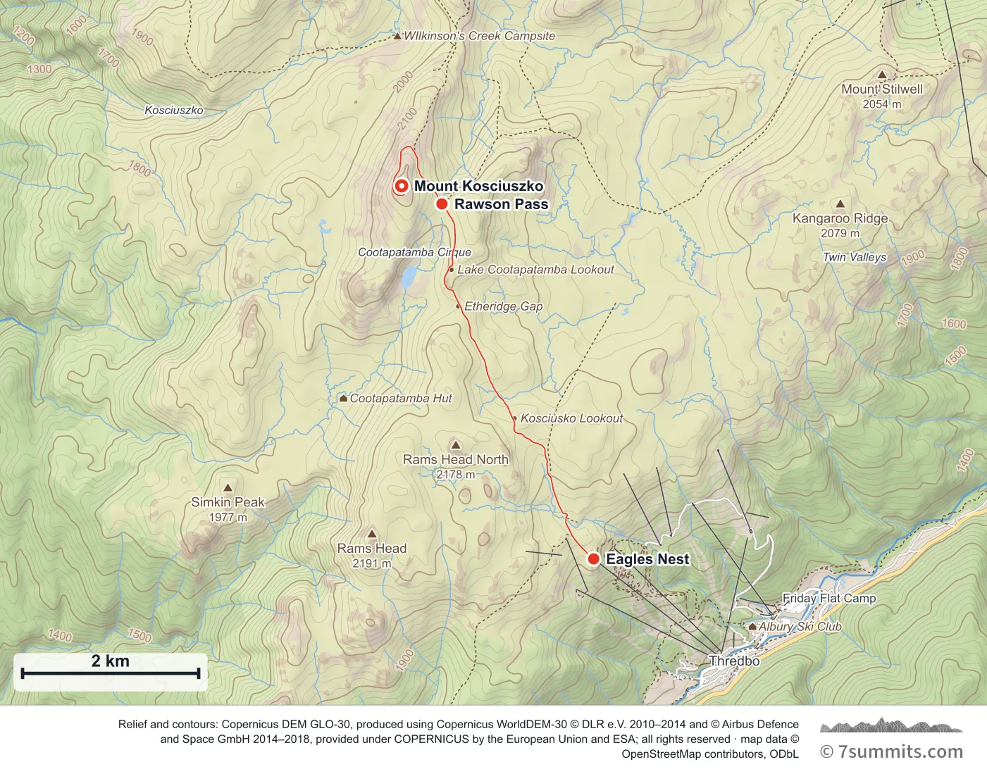
Point at the route or drag along the profile to see the height and the distance walked.
GPX files
Download the Thredbo Summit Walk track
Navigation aid only, not a substitute for your own judgement, current conditions or local knowledge. Elevations are modelled from open terrain data, not surveyed.
Sources, credits and licence
© OpenStreetMap contributors + OSM public GPS traces. Licence: ODbL 1.0. Source data
Waypoints
WGS84 decimal degrees. Elevations are modelled from open terrain data (roughly 20–50 m low on snow and ice), not published camp altitudes: read them as approximate positions, not pitches.
| Waypoint | Latitude | Longitude | m | ft |
|---|---|---|---|---|
| Eagles Nest (chairlift top) (6,332 ft) | -36.49390 | 148.28787 | 1,930 | 6,332 |
| Rawson Pass (6,969 ft) | -36.45767 | 148.26862 | 2,124 | 6,969 |
| Mount Kosciuszko (7,310 ft) | -36.45583 | 148.26351 | 2,228 | 7,310 |
Links to other people’s recordings, hosted by them. Compare and cross-check: never assume any single line is safe.